

Hurricane Irma: an ocean perspective

Text by Dorotea Iovino and Enrico Scoccimarro Centro Euro-Mediterraneo sui Cambiamenti Climatici (Fondazione CMCC), Bologna, Italy
Tropical cyclones (TCs) in their most intense expression (Hurricanes or Typhoons) are the main natural hazards known to humankind. The impressive socio-economical consequences for countries dealing with TCs make our ability in modelling this organized convective structures a key issue to better understand their nature and their interaction with the climate system. The destructive effects of TCs are mainly caused by three factors: strong wind, storm surge and extreme precipitation. These TC induced effects contribute to the annual worldwide damage of the order of billions of dollars and a death toll of thousands of people.
TCs are low pressure systems, developing over tropical warm ocean waters, have organized convection and an associated intense cyclonic surface wind circulation. They collect energy from the ocean through the evaporation flux, then from the associated condensation of water in upward air masses near their center. This energy release in the troposphere originates the well-known “warm core”, causing the extraordinary strong winds at the surface. The very strong winds associated to TCs near the surface cause damage to coastal regions through extreme wind, very intense precipitation and storm surge. Thus, the fundamental role of the ocean in determining Tropical Cyclone activity on the atmospheric component of the climate system merges. The North Atlantic region has the largest number of hurricane-related information, due to the dense ship tracks since the pre-satellite era, leading to the existence of an official archive extending back to 1851. Despite no significant trends have been identified in the observed TC activity in the Atlantic basin since the 19th century, significant trends in TC numbers and intensities have occurred over the past few decades. Following the Saffir-Simpson wind scale) hurricane classes range from Category 1 (at least 118 km/h) to Category 5 (greater than 250 km/h). The extraordinarily large and intense Hurricane Irma is one of the strongest hurricanes ever recorded in the Atlantic with winds peaking at 300km/h. Its powerful winds have kept it a Category 5 for more than two days. IRMA hurtled toward Cuba and the Bahamas this afternoon after leaving a trail of devastation in the Caribbean, while an anxious South Florida and Miami prepared for what could be a major hit by the weekend. IRMA is expected to bring up to 6m storm surges to the Bahamas, before moving to Cuba and plowing into southern Florida as a very powerful Category 4 on Sunday, with storm surges and flooding due to begin within the next 48 hours.
Hurricanes draw energy from the ocean in the form of sensible and latent heat fluxes that result from very high wind speeds and a rather small temperature difference between the subtropical atmosphere and warmer sea surface, typically only a few ◦C. The thermal and dynamical structure of the ocean is affected by surface wind stresses through two main atmosphere–ocean feedbacks. The first (positive) feedback is driven by the latent heat associated with the increased evaporation rate and leads to an enhancement of the available energy for TC development, and is responsible for the auto-fuelling mechanism behind the process. The second (negative) feedback is due to the cold-water upwelling induced by the increased wind stress at the ocean surface and by the cooling of surface layers due to the shear-induced mixing at the base of the mixed layer. The induced cooling of the sea surface leads to a weakening of the cyclone intensity due to the reduction of the total heat flux into the atmosphere. This cooling effect is a function of the initial ocean condition, TC intensity, travelling speed and size. Slow TCs tend to provide a more pronounced cooling effect on the ocean than fast moving TCs, same as TCs transiting over region with a shallow mixed layer (such as the ~40m deep mixed layer in the region where Hurricane IRMA is transiting). In addition, after the storm passage, the Sea Surface Temperature is restored to the climatological values within few weeks, subtracting additional heat to the atmospheric component. The described self-induced cooling effect has a really important role in determining TC intensity and a realistic representation of such effect on the ocean is pivotal in predicting TC intensity before landfall.
The CMCC global ocean forecasting system, GOFS16, based on a NEMO 1/16° eddying ocean and 3DVar assimilation scheme, allows us to quantify the IRMA induced cooling on the ocean, indicating how large the weakening effect will be prior the hurricane landfall. From the CMCC ocean forecast, Irma is expected to reach South Florida by early Sunday September 10th. As shown in figure, the SST cooling forecasted for the day of IRMA landfall is of the order of 2° off the eastern Florida coast, less pronounced than the value forecasted for KATIA (up to ~3°) hurricane developing in these days in the Gulf of Mexico. The more pronounced TC induced cooling effect on KATIA can be explained thanks to the lower translation speed of this perturbation compared to Hurricane IRMA. On the other hand, the depth of the mixed layer below the storm results comparable in the two cases. Based on the CMCC global ocean forecast system, we expect a partial but not fundamental role of the ocean cooling in reducing IRMA intensity before landfall, consistently with NCEP Operational HWRF Forecast (http://www.emc.ncep.noaa.gov) track projections. In fact, despite the sufficiently high cooling magnitude, due to the fast translation speed of IRMA the major cold wake created by TC is projected to be left behind, not affecting hardly IRMA intensity. A more pronounced weakening effect due to the sea surface cooling is expected for Hurricane KATIA.
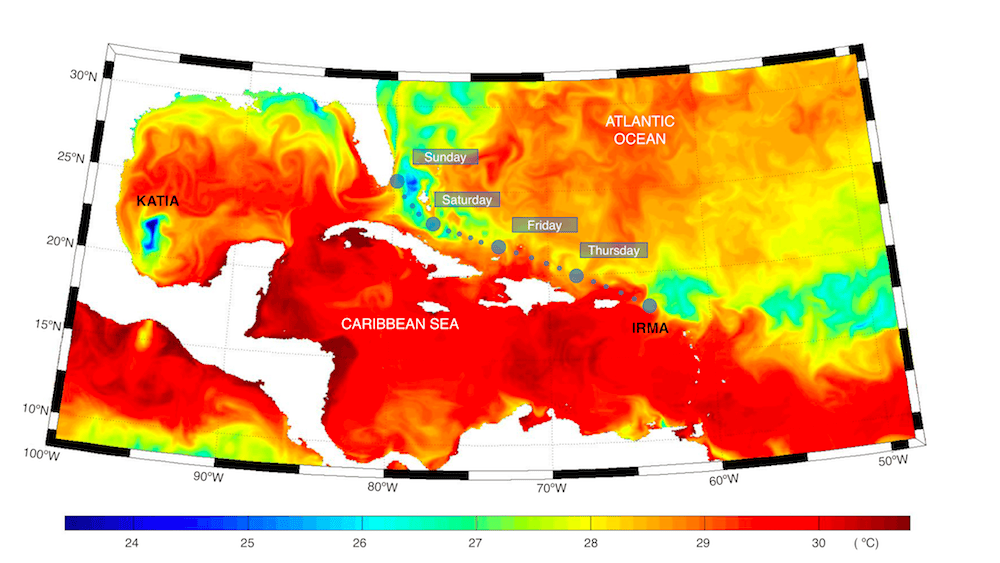
Daily sea surface temperature (for Sunday September 10th) as forecasted by the CMCC global ocean forecasting system on Thursday September 7th. Large (small) circles indicate the IRMA position (forecasted path). Katia location is also indicated. Click the picture to enlarge.
Related references
- Iovino, D., Masina, S., Storto, A., Cipollone, A., and Stepanov, V. N.: A 1/16° eddying simulation of the global NEMO sea-ice–ocean system, Geosci. Model Dev., 9, 2665-2684, https://doi.org/10.5194/gmd-9-2665-2016, 2016.
- Scoccimarro E. et al.: Effects of Tropical Cyclones on Ocean Heat Transport in a High-Resolution Coupled General Circulation Model. J. Climate, 24, 4368–4384. 2011.
- Scoccimarro, E., S. Gualdi, G. Villarini, G. Vecchi, M. Zhao, K. Walsh, and A. Navarra: Intense precipitation events associated with landfalling tropical cyclones in response to a warmer climate and increased CO2. J. Climate, 27, 4642-4654. 2014.
- Scoccimarro E., P.G. Fogli. K. Reed, S. Gualdi, S.Masina, A. Navarra: Tropical cyclone interaction with the ocean: the role of high frequency (sub-daily) coupled processes. Journal of Climate , doi: 10.1175/JCLI-D-16-0292.1. 2017.
- Storto, A., S. Masina, and A. Navarra (2015) Evaluation of the CMCC eddy-permitting global ocean physical reanalysis system (C-GLORS, 1982–2012) and its assimilation components. Q.J.R. Meteorological Society, doi:10.1002/qj.2673