

The Hurricane JOSE fingerprint on the OCEAN
Text by Enrico Scoccimarro and Dorotea Iovino Centro Euro-Mediterraneo sui Cambiamenti Climatici (Fondazione CMCC), Bologna, Italy.
First there was Harvey. Next came Katia and Irma. And now Hurricane Jose is in the middle of the Atlantic Ocean. The peak of the Atlantic tropical cyclone season (September) seems to be particularly active this year. Jose is the fourth threatening hurricane to form over the Atlantic in the past few weeks. With maximum sustained winds of 165 km/h with even stronger gusts, it is expected to stall over the Atlantic for the next several days.
As for Hurricane IRMA, we describe Jose’s impact on the ocean surface properties analysing the CMCC global ocean forecasting system, GOFS16. In the IRMA case, our system forecasted a hurricane-induced sea surface cooling of few Celsius degrees before landfall. This “relatively small” anomaly was mainly due to the IRMA fast translation speed, able to smooth out the effects on sea surface temperature (SST) expected for CAT-5 surface winds.
JOSE has been downgraded to a Category 3, and increased wind shear might slowly weaken it over the next couple of days, but it will most probably remain at hurricane strength. With a lower translation speed, JOSE will stall out the open ocean, expected to make a clockwise loop between Bermuda, the Bahamas, and Puerto Rico in the next 5 days (based on NOAA forecast). This peculiar track will probably result in an intense Hurricane/Ocean interaction.
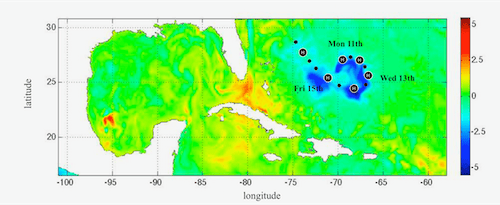
The GOFS16 forecasting system shows a large SST reduction on Friday September 16th, with respect to today temperature, Monday 11th along the Jose path. Whereas tropical cyclone tracks are mainly determined by their large-scale atmospheric environment, storm intensity is influenced to a greater degree by smaller-scale features in both the atmosphere and ocean. Thus, a better understanding of the TC interaction with the Ocean is fundamental to determine the potential intensification or weakening of the hurricane. The SST anomaly induced by JOSE is greater than 5 °C, suggesting this hurricane as one of the best-case study, within the satellite era, for studying the interaction between the Tropical Cyclone and the Ocean.
Together with the aforementioned cooling, a warming pattern appears over the final part of IRMA and KATIA tracks. There, the ocean subtracts heat from the atmosphere, due to the typical restoring tendency to climatological values after the storm passage. The emerged picture (Figure 1), projected for the end of the current week, is a great example of concurrent pre and post hurricane conditions in the Atlantic Ocean.
Difference of sea surface temperature between Saturday September 16th and Monday September 11th. The large negative anomaly is collocated with JOSE, while the large positive anomalies are related to the passage of IRMA and KATIA. Model data from the CMCC global ocean forecasting system at 1/16° of horizontal resolution.
Read also the article by the same authors “Hurricane Irma: an ocean perspective” on the CMCC’s blog TEC.
Related references:
- Iovino, D., Masina, S., Storto, A., Cipollone, A., and Stepanov, V. N.: A 1/16° eddying simulation of the global NEMO sea-ice–ocean system, Geosci. Model Dev., 9, 2665-2684, https://doi.org/10.5194/gmd-9-2665-2016, 2016.
- Scoccimarro E. et al.: Effects of Tropical Cyclones on Ocean Heat Transport in a High-Resolution Coupled General Circulation Model. J. Climate, 24, 4368–4384. 2011.
- Scoccimarro, E., S. Gualdi, G. Villarini, G. Vecchi, M. Zhao, K. Walsh, and A. Navarra: Intense precipitation events associated with landfalling tropical cyclones in response to a warmer climate and increased CO2. J. Climate, 27, 4642-4654. 2014.
- Scoccimarro E., P.G. Fogli. K. Reed, S. Gualdi, S.Masina, A. Navarra: Tropical cyclone interaction with the ocean: the role of high frequency (sub-daily) coupled processes. Journal of Climate , doi: 10.1175/JCLI-D-16-0292.1. 2017.
- Storto, A., S. Masina, and A. Navarra (2015) Evaluation of the CMCC eddy-permitting global ocean physical reanalysis system (C-GLORS, 1982–2012) and its assimilation components. Q.J.R. Meteorological Society, doi:10.1002/qj.2673