
VISIR, a numerical model designed for operational ship voyage planning, has been developed at CMCC since 2012. Leveraging a graph-search methodology, VISIR incorporates dynamic meteo-oceanographic fields. Its versatility extends to navigating coastal and archipelagic regions. The model and its accompanying software are comprehensively documented in peer-reviewed publications.
There are two siblings in the VISIR family: VISIR-1, coded in Matlab, and VISIR-2, in Python.
VISIR-2 presently (January 2024) powers both a service for least-CO2 routes of a ferry (GUTTA-VISIR) and one for leisure boats (FRAME-VISIR) in the Adriatic Sea. VISIR-1 used to power a service (VISIR-nav) for on-demand route optimization in the Mediterranean Sea.
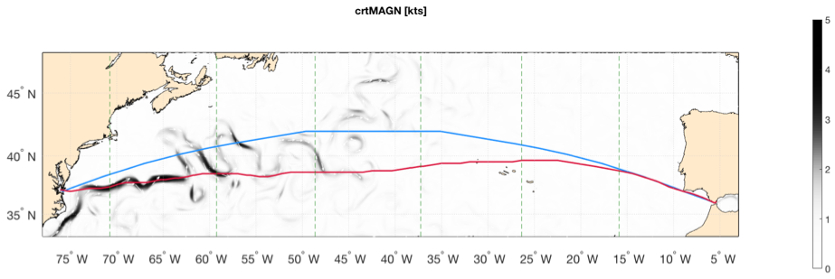
Figure 1. Least-distance (blue) and least-time track (red) for the Norfolk (USA) – Algeciras (Spain) route accounting for both waves and ocean currents. Current magnitude is displayed as shading and its direction as white arrows. Vertical panel stripes refer to daily timesteps of the optimal tracks – the interface between stripes is marked by a green dashed line. The least-time track is 38 nautical miles longer but 5 hours faster than the least-distance track. Departure date: 2018-06-21. Source: Mannarini and Carelli (2019).
VISIR is freely accessible as open-source software. In addition to the Zenodo communities for distribution of source code, datasets, and manuals linked above, you can find news, publications, and details about its funding projects on the website: https://www.visir-model.net/.
Contacts