
The Medicane Ianos fingerprint sweeps across Greece
An article by Coppini G. (1) , Clementi E.(1), Federico I.(1), Scoccimarro E.(1), Lecci R.(1), Pinardi N.(2), Navarra A.(1), Gualdi S.(1)
(1) CMCC Foundation, Euro-Mediterranean Center on Climate Change, Italy
(2)University of Bologna, Department of Physics and Astronomy, Italy
Two CMCC high-resolution forecasts and analysis systems clearly captured the path of Ianos while representing the impact of Medicane on ocean currents and sea level and predicting the wave height increase and evolution of this extreme event. A reliable and innovative solution for coastal storm surge alerts several days in advance.
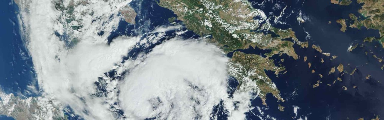
After the 2018 Medicane Zorbas, in these days a new Medicane called Ianos has formed offshore the African coasts on the 17th September, crossed the Ionian Sea and reached the Greek coastal areas of the western Peloponnese. From there, this rare hurricane-like storm swept across Greece through central Thessaly, hitting mainly areas around the cities of Karditsa and Farsala: an estimated 5,000 properties were said to have been flooded in the city of Karditsa alone. The Greek fire service rescued almost 1,000 people in the Region. Then Ianos headed south towards the island of Crete while losing intensity in its south-eastward shift.
Ianos brought high winds reaching 120km/h, torrential rain and flooding which caused the death of three people in Greece and huge damages to houses and streets.
Medicanes are cyclones producing intense mesoscale vortices over the Mediterranean Sea having a tropical-like structure but a rather small size, that can produce significant damage due to the combination of intense winds and heavy precipitation. Medicanes are hybrid systems having characteristics representative of both frontal extra-tropical systems and tropical cyclones (Miglietta et al., 2011; 2013); the horizontal extent is generally confined to a few hundred km while the intensity rarely exceeds category 1 of hurricane strength (Cavicchia et al., 2014, Miglietta and Rotunno 2019).
The Ianos Medicane was clearly captured by the atmospheric forecast and analysis of ECMWF model and the MedFS forecast and analysis system (http://medfs.cmcc.it/), which is the Mediterranean Sea Monitoring and Forecasting Centre (MED-MFC) of the Copernicus Marine Monitoring and Environment Service (CMEMS) produced by CMCC. MedFS was capable to clearly represent the impact of the Medicane on the ocean currents and sea level.
VIDEO – MedFS Surface currents forecast provided on the 17th September 2020
VIDEO – MedFS Significant wave height forecast provided on the 17th September 2020
VIDEO – ECMWF 10m winds
As shown in the figures 1-4, representing maps and time series of surface velocities and sea level on the 17th and 18th September, MedFS has predicted a seven-fold increase of surface currents and a 25cm sea level surge. What is interesting to notice is the increase of the sea level surge at the coasts to 30 cm and an even larger increase of the currents near the coasts.
Figure 1. 17th September 2020: Sea surface currents intensity [m/s] and direction (left), Sea level [m] (right):

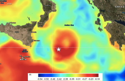
Figure 2. Sea surface currents [m/s] (left) and sea level [m] (right) time evolution for the white star point in Figure 1


Figure 3. 18th September 2020, Sea surface currents intensity and direction(left), Sea level [m] (right)
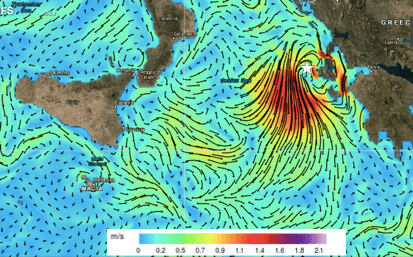
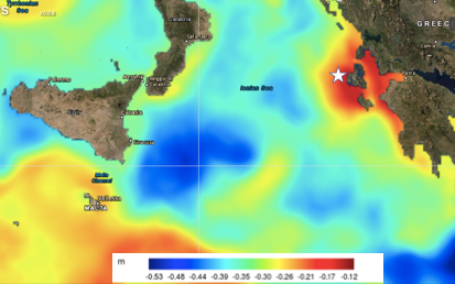
Figure 4. Sea surface currents [m/s] (left) and sea level [m] (right) time evolution for the white star point in Figure 3


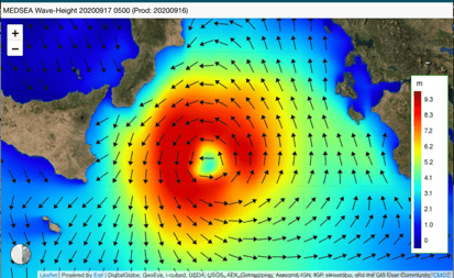
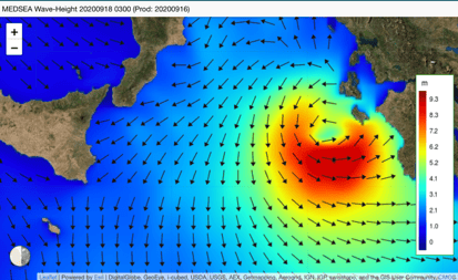
The MedFS has also predicted the wave height increase and evolution under Medicane Ianos with maximum height close to 9 m as shown below.
Figure 5. Significant wave height [m] and direction on the 17th (left) and 18th (right) September 2020.
Furthermore, high-resolution forecasts have been produced by means of limited-area modelling system, nested in MedFS forecast. The model, based on a spatial resolution ranging from 3km to 500m in the coastal waters of Zakynthos and Kefalonia, includes also tidal forcing at boundary. Fig. 6 shows the map of sea surface currents (a) and sea level (b) on 18th September 2020 at 5:00 am, when the highest surge is forecasted. In Fig. 6(c) we also report, for different hotspots surrounding the two islands, the timeseries of model sea level compared with the astronomical tidal prediction for the area. The high-resolution forecasts show a displacement of 25-30cm of sea level with respect with highest astronomical tidal excursion, due to the surge induced by the Medicane.
In conclusion, we show that MedFS and nested limited area models offer a reliable and innovative solution for coastal storm surge alerts several days in advance.
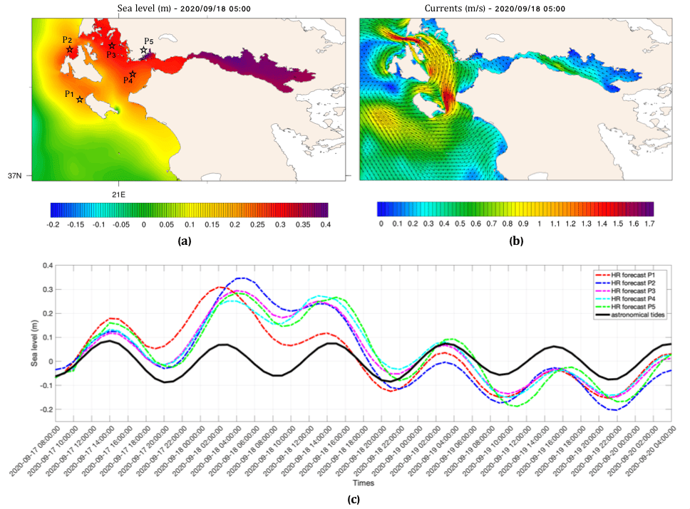
Figure 6. Map of sea level (a) and sea surface currents (b) on 18th September 2020 at 5:00 am. Timeseries of sea level high-resolution forecast [m] in different hotspots near Zakynthos and Kefalonia Islands.
References:
Miglietta, M. M., A. Moscatello, D. Conte, G. Mannarini, G. Lacorata, and R. Rotunno (2011). Numerical analysis of a Mediterranean ”hurricane” over south‐eastern Italy: Sensitivity experiments to sea surface temperature, Atmos. Res., 101, 412–426.
Miglietta, M.M., D. Mastrangelo, D. Conte (2015). Influence of physics parameterization schemes on the simulation of a tropical-like cyclone in the Mediterranean Sea. Atmos. Res. 153, 360-375. http://dx.doi.org/10.1016/j.atmosres.2014.09.008
Miglietta, M.M. and R. Rotunno (2019). Development mechanisms for Mediterranean tropical‐like cyclones (medicanes). Quarterly Journal of the Royal Meteorological Society, https://doi.org/10.1002/qj.3503
Cavicchia L. and H. von Storch, 2014. The simulation of medicanes in a high-resolution regional climate model. Climate Dynamics, 39:2273–2290, 2012.
Read also Giovanni Coppini’s interview (in Italian) on Corriere.it