
Aridity and drought: Here is the global, spatial detailed database on current and projected water demand
Shifts in temperature and rainfall patterns are expected to increase pressure on water availability in many parts of the world, while inundating others. Anticipating where and how these changes may occur is essential for managing risks related to food production, water supplies, ecosystems, and human health. The results of a new study, led by CMCC, reveal a general pattern of intensifying aridity, particularly in regions already exposed to periodic drought or water scarcity, and provide a structured, high-resolution dataset that can support environmental assessments and land-use planning.
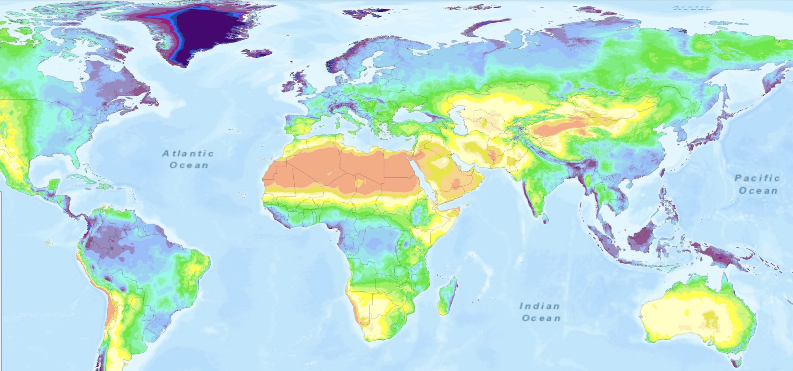
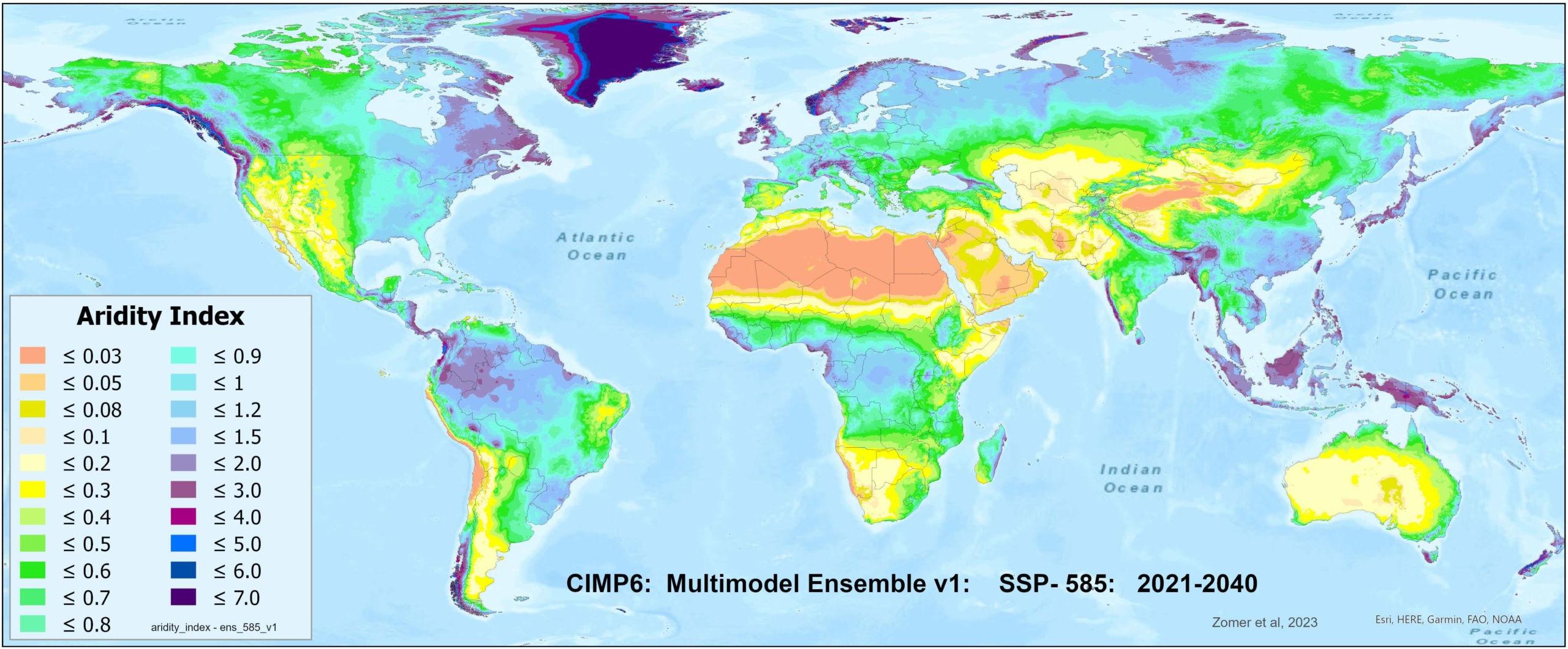
A recent peer-reviewed study, led by CMCC in collaboration with an international team of researchers, provides a global assessment of future climatic water balance focusing on two key indicators: potential evapotranspiration, which represents the atmospheric demand for water, and the aridity index, which compares rainfall to potential water loss.
At the core of the study is the release of a high-resolution (approximately 1 kilometer) dataset that offers global, spatially detailed estimates of current and projected water demand and aridity under four climate change scenarios, for two averaged historical time periods, and two future averaged time periods (2021-2040; 2041-2060).
The database can therefore serve as a resource for a wide range of users – from scientists and land managers to national planning agencies – especially in regions where access to reliable future climate data is limited. While the accompanying analysis highlights broad trends in drying and increasing climatic water stress, the database itself is intended to enable more localized assessments and support planning, monitoring, and decision-making at national and sub-national scales.
“The availability of such a global, open-access resource is particularly timely as countries and communities seek practical tools to adapt to changing environmental conditions,” says lead author and CMCC researcher Robert Zomer. “By linking the latest climate model projections with well-established measures of water demand and dryness, this dataset provides a clear, spatially detailed picture of how the global climate system may reshape ecological and agricultural conditions over the coming decades.”
The database offers a spatially comprehensive framework for identifying where conditions are likely to become drier or wetter relative to historical baselines, revealing a general pattern of increasing potential evapotranspiration across nearly all regions, driven by rising temperatures, with accompanying increases in aridity in many areas, even where precipitation may increase.
This points to a broad trend of intensifying aridity, particularly in regions already exposed to periodic drought or water scarcity. In fact, dryland zones are expected to expand, and transitions between major climate zones – such as from humid to semi-arid – are projected in several parts of the world. These changes are likely to affect ecological stability, land suitability, agriculture, and freshwater availability.
 The analysis emphasizes the global consistency of these trends and their spatial patterns, whilst also highlighting the utility of the datasets for region and locally-specific applications. The database underlying these results is designed to support further analysis and applications at regional and local levels, providing a resource for modeling, planning, and climate risk assessment.
“One of the strengths of this work is that it offers a consistent, high-resolution dataset that is openly available and usable across disciplines and geographies,” says Prof. Xu Jianchu, co-author of the study from the Chinese Academy of Sciences.
While similar datasets have been developed previously, this work extends them by incorporating updated climate model inputs and offering increased spatial detail. It applies a uniform methodology across all land areas, allowing for direct comparison between regions and across timeframes.
“As climate pressures increase unevenly across the globe, having comparable data for all regions is essential for understanding emerging risks and supporting informed responses,” says Donatella Spano, co-author of the study and CMCC researcher .
Although the study includes a global-scale analysis of projected drying trends, its primary contribution is the public release of a structured, high-resolution dataset intended to support further research and application. The format and resolution are designed to facilitate integration into environmental assessments and land-use planning, particularly in regions where future climate projections at relevant spatial scales are limited.
“This information can support long-term planning in regions where decisions about land use, water management, or restoration must now account for future climatic shifts,” says Antonio Trabucco, co-principle investigator and CMCC researcher.
For more information:
The database was jointly developed as part of a long-standing and close collaboration between CMCC and the Center for Mountain Futures at the Kunming Institute of Botany, Chinese Academy of Sciences. This long-standing collaboration includes previous and recent work with the Department of Agricultural Sciences at the University of Sassari, Sardinia, Italy and the National Biodiversity Future Center in Palermo, Sicily, Italy. . The Future_Global_AI_PET Database was developed as part of a larger EU Horizon 2020 funded project on Global Environmental Stratification. The release of the database reflects an ongoing effort by CMCC and its partners to provide scientifically grounded, accessible tools to support global responses to climate change.
Zomer RJ, Xu J, Spano D and Trabucco A. CMIP6-based global estimates of future aridity index and potential evapotranspiration for 2021-2060 [version 4; peer review: 3 approved]. Open Res Europe 2025, 4:157 https://doi.org/10.12688/openreseurope.18110.4