The first interactive classification of extreme events in Italy. Day by day information, maps, bulletins, high-resolution climate analysis and impact reports: CMCC celebrates the Earth Day by releasing a new online climate service.
Ongoing drought throughout Italy, the Mediterranean cyclone that hit Sicily last October, and flooding in Liguria just a few weeks earlier. These are some of the intense weather events that have been affecting Italy, causing significant socio-economic impacts.
From the insurance and infrastructure sectors to the spheres of policy and communication, various stakeholders need more detailed information on these kinds of events, which are expected to increase in both frequency and intensity due to climate change. To meet the needs of these players, the CMCC Foundation has created “Extreme Events Monitoring”, the first complete collection and classification of extreme events to have occurred in Italy to date.
The service complements the CLIME platform (www.dataclime.com) – which provides solutions and climate data for users with different backgrounds and needs – by handling the entire information production chain.
The new feature allows for a dynamic and interactive visualization of past extreme events in Italy, classifying them as either ‘moderate’, ‘severe’ or ‘extreme’, according to their characteristics and in relation to the specific climate of the area considered. This allows for the construction of a record of both climatic analysis of these events and the socio-economic impacts generated by them. This makes it possible to observe and verify the evolution of ongoing climate change by looking at the growing frequency and intensity of extreme events.
Moreover, for the most significant events, the Extreme Events Monitoring service provides customized weather reports that describe the evolution of factors that led to the specific event, as well as links to news articles describing their impacts.
For many stakeholders, this kind of information has an important economic value. Owners of infrastructure insured against extreme events will be interested in verifying whether an event that caused damage to their property was ‘exceptional’, as this will determine what kind of compensation they are entitled to. On the other hand, insurers will be keeping an eye on the increasing frequency of extreme events that impact their insurance policy holders so as to calibrate the conditions of their premiums and claims over time, as these will need to adapt as climate change worsens.
The service is based on the use of data obtained from climate reanalyses, a powerful tool in which numerical models, combined with historical observational data provided by different sources (satellites, in situ stations, etc.), allow for the reconstruction of past weather and climates. In particular, this application is based on the use of the fifth generation of reanalysis (ERA5), publicly available within the Copernicus C3S platform (which provides atmospheric variables at a spatial resolution of approximately 30 km) and ERA5@2km. The latter, produced by CMCC, provides high-resolution climate data (at 2 km), allowing for local level studies, particularly in urban areas, and even reconstructing the history of events in localized areas.
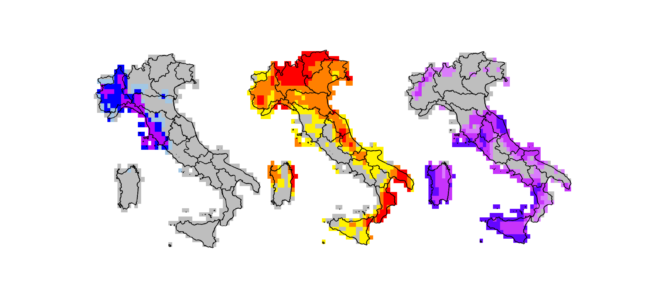
Through an intuitive interface, the user can select the period and type of event of interest (anomalies of warm and cold, heavy rainfall, drought and storms associated with different atmospheric parameters) as well as the desired spatial resolution (30 km or 2 km). A map will then be displayed showing the areas affected by the chosen event and indicating its intensity with a colour gradient. It is also possible to download a file that provides this data in text format or which can be used in other geo-referenced platforms.
The figures below, downloaded directly from the platform, show short-term drought data (calculated over the last three months) recorded in February and March 2022 across Italy, on a 30km spatial scale.