
Safe and efficient navigation in the Mediterranean Sea
How to find the best nautical routes to sail in the Mare Nostrum? The answer is VISIR, a system developed thanks to the collaboration between advanced research and users. Designed for various kinds of both motor- and sailboats, the system is now available online and as a mobile application on Google Play and Apple Store. Two studies recently published describe its features, functionalities and the science at its basis.
The use of marine weather forecasts for route recommendations has been since long recognized. However, due to the limited spatial and temporal resolution of the oceanographic forecast products, so far applications have dealt mainly with large ocean-going motor vessels or racing and leisure sailboats, mainly in a regime of open-sea navigation. In recent years, the operational availability of coastal observatories and high-resolution ocean forecast products have paved the way for applications to be used even in enclosed seas and coastal waters.
Visir is the Italian word for “vizier”, who was a high-ranking political advisor in the Arab world. Its etymology seems to be related to the ideas of “deciding” and “supporting”.
Therefore the word VISIR was chosen by CMCC Foundation researchers for christen a new ship routing decision support system (DSS) designed and implemented during the last 4 years.
VISIR (discoVerIng Safe and effIcient Routes) is an innovative and easy-to-use product of the industrial research. It provides safe and efficient nautical routes all over the Mediterranean Sea. It is also used in an operational decision support system (DSS) for optimal ship routing designed and implemented in the frame of the TESSA (TEchnology for Situational Sea Awareness) project by a team of researchers of the CMCC Foundation and Links Management and Technology S.p.A.
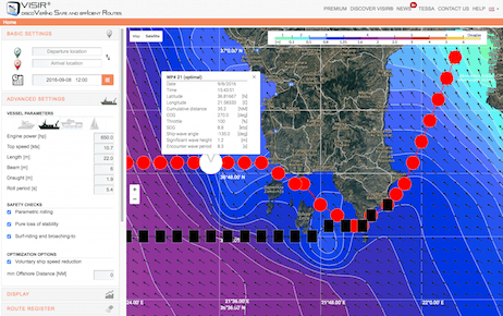
An optimal route computed by VISIR-I (available at https://av.tib.eu/media/18087?0)
VISIR employs certified weather-marine forecasts and state-of-the-art modelling in order to find fast and safe routes for various kinds of both motor- and sailboats cruising in the Mediterranean Sea. Continously updated and improved, VISIR is meant to provide an open-access, user-oriented, cross-channel system for on-demand computation of optimal routes. The service is available as a mobile application on Google Play and Apple Store and online as a web application. Moreover, the source code of the model is made free and open-access and is documented in two open-review and open-access scientific journals.
In an article published on Geoscientific Model Development, the authors (among them, CMCC Foundation researchers G. Mannarini, N. Pinardi and G. Coppini) described in the detail the model behind the VISIR operational system.
“What is unique about VISIR”, explains G. Mannarini, lead author of the study, “is its transparent nature. VISIR has been in fact developed thanks to the inputs from several relevant nautical stakeholders, and collecting suggestion and criticism from conferences and meetings all around Europe in the time span 2012-2015. VISIR can be further improved by scientists who download and use its source code”.
In another paper published on Natural Hazards and Earth System Sciences,
the authors described the technological infrastructure developed for operating VISIR as a DSS. Starting from the VISIR model, in fact, a DSS for on-demand computation of optimal ship routes in the Mediterranean Sea has been developed. The system works for both motorboats and sailboats of various sizes taking into account the safety of navigation, vessel stability and the minimization of the route duration. The user can specify departure date and time, departure and arrival locations, vessel type, and other parameters. The routes are displayed on top of the forecast fields.
“In contrast to most existing products” Mannarini said “in its first version VISIR addresses ship routing tasks for medium and small size vessels navigating in coastal waters, where topological issues, such as islands, are more relevant than in ocean-passages”.
The system may be used operationally thanks to the TESSA infrastructure that provides daily updated forecasts, state-of-the-art visualization of the environmental fields while supporting on-demand personalized route computations.
Furthermore, VISIR is accessible even from smartphones and tablets, and the computations are performed on a remote server. This way, bandwidth requirements and device computational resources are kept at a minimum.
“In conclusion”, Mannarini said, “VISIR is nowadays a community model that can be improved and made even more realistic thanks to scientists and professionals in various fields of expertise such as navigation, computer science and mathematics”. The European flagship initiative for funding excellent research Horizon-2020 partially supports VISIR development with the AtlantOS project. The authors aim at fostering and strenghtening a global community of developers of the source code of VISIR model.
References
VISIR can be accessed through a web interface (www.visir-nav.com) and mobile applications for both iOS and Android devices. The computer code used by VISIR for computing optimal route is now open and free (www.visir-model.net).
If reporting on this story include a link to the papers:
- Mannarini G., Pinardi N., Coppini G., Oddo P., Iafrati A.
VISIR-I: small vessels – least-time nautical routes using wave forecasts
2016, Geoscientific Model Development, 9, 1597-1625, DOI: 10.5194/gmd-9-1597-2016
- Mannarini, G., Turrisi, G., D’Anca, A., Scalas, M., Pinardi, N., Coppini, G., Palermo, F., Carluccio, I., Scuro, M., Cretì, S., Lecci, R., Nassisi, P., and Tedesco, L.:
VISIR: technological infrastructure of an operational service for safe and efficient navigation in the Mediterranean Sea
2016, Natural Hazards and Earth System Sciences, 16, 1791-1806, DOI: 10.5194/nhess-16-1791-2016, 2016
The team is composed of Gianandrea Mannarini (CMCC Foundation [CMCC], Lecce, Italy), Nadia Pinardi (University of Bologna, and CMCC Bologna, Italy), Giovanni Coppini (CMCC Lecce), Giuseppe Turrisi (CMCC Lecce).